Posts

Recent Published Post

তলোয়ার

Image
তলোয়ার হলো একটি প্রান্তীয় ধারালো অস্ত্র, যা সোজা কিংবা বাঁকানো হতে পারে। তলোয়ারের আকার-আকৃতি, সংজ্ঞা, এবং ঐতিহাসিক যুগ ভৌগোলিক অঞ্চল অনুসারে ভিন্নতা রয়েছে। ঐতিহাসিক তথ্যসূত্র অনুযায়ী, তলোয়ার ব্রোঞ্জ যুগে বিকশিত হয়েছিল বলে জানা যায় (?)। ছোরা থেকে বিবর্তিত হয়ে তলোয়ারের প্রাচীনতম নমুনাগুলো প্রায় ১৬০০ খ্রিস্টপূর্বাব্দের। পরবর্তী লৌহ যুগের তলোয়ার ছিল ক্রস গার্ড ছাড়া এবং আকারে ছোট। পরবর্তী রোমান সেনাবাহিনীতে বিকশিত হওয়ার সাথে সাথে স্পাথা (ধারালো অস্ত্র) মধ্যযুগের ইউরোপীয় তলোয়ারের পূর্বসূরী হয়ে উঠে। আরব সাইফ, ফার্সি শমসের, তুর্কি কিলিজ এবং আফগান পুলয়ারের মতো তলোয়ারগুলো মধ্য এশিয়ার তুরস্কের উন্নত বাঁকানো অস্ত্র থেকে উদ্ভূত হয়েছে বলে জানা যায়। উপমহাদেশের অন্যতম প্রাচীন অস্ত্র এ তলোয়ার আধুনিক বাংলাদেশ, ভারত, পাকিস্তান, ও আফগানিস্তানেও পাওয়া যায়।
Sword

Image
 A sword is a sharp-edged weapon, which can be straight or curved. Swords vary in shape, definition, and historical era by geographic region. According to historical sources, the sword was developed in the Bronze Age (?). The earliest examples of swords, which evolved from daggers, date to around 1600 BC. Swords were without cross guards and smaller in size in the later Iron Age. As developed in the later Roman army, the spatha (sharp weapon) became the precursor to the European sword of the Middle Ages. Swords such as the Arab saif, the Persian shamser, the Turkish kiliz, and the Afghan pulyar are known to have evolved from the curved weapons developed in Central Asian Turkey. This sword, one of the oldest weapons of the subcontinent, is also found in modern Bangladesh, India, Pakistan, and Afghanistan.

এক নজরে বাংলাদেশ

 বাংলাদেশকে জানতে আগ্রহী প্রার্থী ও অন্যান্য পাঠকদের জন্য এক নজরে বাংলাদেশ সম্পর্কে নিচে তুলে ধরা হল:- ১. বাংলাদেশ একটি স্বাধীন রাষ্ট্র হিসেবে আত্মপ্রকাশ করে - ১৯৭১ সালের ১৬ ডিসেম্বর। ২. সরকারি নাম - গণপ্রজাতন্ত্রী বাংলাদেশ। ৩. রাজধানী - ঢাকা। ৪. সরকার ব্যবস্থা - সংসদীয় সরকার। ৫. রাষ্ট্রপ্রধানের দায়িত্ব পালন করেন - রাষ্ট্রপতি। ৬. সরকার প্রধানের দায়িত্ব পালন করেন - প্রধানমন্ত্রী। ৭. ভৌগোলিক অবস্থান - ২০°৩৪´ উত্তর থেকে ২৬°৩৮´ উত্তর অক্ষাংশ এবং ৮৮°০১´ পূর্ব থেকে ৯২°৪১´পূর্ব দ্রাঘিমাংশ। ৮.  আয়তন - ১,৪৭,৫৭০ বর্গকিলোমিটার। ৯. অবস্থান - পশ্চিমে ভারতের পশ্চিমবঙ্গ রাজ্য, উত্তরে ভারতের পশ্চিমবঙ্গ, আসাম ও মেঘালয় রাজ্য, পূর্বে ভারতের আসাম, ত্রিপুরা ও মিজোরাম রাজ্য ও মায়ানমার এবং দক্ষিণে বঙ্গোপসাগর। ১০. আন্তর্জাতিক স্থলসীমার দৈর্ঘ্য - প্রায় ২,৪০০ কি.মি., এর মধ্যে ৯২% ভারতের সাথে এবং বাকি ৮% মায়ানমারের সাথে। উপকূলীয় সীমারেখার দৈর্ঘ্য ৪৮৩ কি.মি. এর অধিক। ১১. ভূ-খন্ডগত সমুদ্রসীমা - উপকূল থেকে ১২ নটিক্যাল মাইল (২২.২২ কি.মি.) পর্যন্ত। ১২. অর্থনৈতিক সমুদ্রসীমা - উপকূল থেকে ২০০ নটিক্যাল মাইল (৩৭০

Dhananjay Math | Cumilla

Image
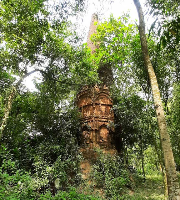
  Dhananjay Math, one kind of memorial temple, is located in the village called Dhananjay of Panchthubi Union of Adarsh Sadar Upazila under Comilla District. The geo-coordinate of this ancient Math is 23°29'55.0"N 91°12'12.0"E (23.498600, 91.203340). Location map of Dhananjay Math ‍at Panchthubi in Cumilla District. Dhananjaya Math built on an octagonal ground plan. The Math is approximately 15 meters high from the plain. Each side of the octagonal math measures 1.5 meters. The math has an entrance on the south wall. The width of the entrance is 0.95 m and height 2.10 m. Lime mortar and thin brick was used to build the math. The outer walls without plaster of the math feature semi-circular arch designs with various geometric designs. The octagonal math gradually tapers up from the middle. Inner wall and Celling of Dhananjay Math ‍at Panchthubi. Relatively large bricks are used in the foundation of the math. The brick used in the temple foundation  measures 27 cm. × 24

Isostasy Theory of Aren Diacen Pratt (A. D. Pratt)

Image
The theory of Isostasy is based on the idea that there is a balance between the high mountains and low plateaus and plains of the earth. Geologists have presented this theory of Isostasy in various ways. Geologist G. B. Airy presented a Isostasy theory about the earth's equilibrium. In 1859, geologist Aren Diacen Pratt (A. D. Pratt) presented another theory of Isostasy against this theory given by Airy. The theory of Isostasy presented by A. D. Pratt mensioned below: A. D. Pratt's theory: According to geologist A. D. Pratt, the density of all parts of the earth is not equal. Pratt states in his theory that all parts of the Earth's solid surface are floating on the same plane above the fluid substratum inside the Earth. However, the surfaces of the earth's solid ground are located at different heights and have created equilibrium conditions. Pratt also points out that the parts of the Earth's solid surface that have the lowest density are the parts that elevated mor